

Why is the Zanskar valley of Kashmir special for tourists and research scholars? This field museum provides evidence of millions of years…

India has a rich geological heritage, making it a truly unique country. As urbanization and industrialization continue to advance in every direction, there is a growing concern that our geological treasures may be at risk of being lost. Without the formulation of robust policies and the implementation of stringent measures, we stand to lose this invaluable heritage, leaving nothing for future generations to inherit.The conservation of geological heritage is imperative because these sites hold significant geological importance. They offer structural, stratigraphic, paleontological, and geomorphological insights into their respective areas. Such information aids in understanding the area's origin, the paleoclimate of its era, and sheds light on Earth's evolution and palaeosciences. Furthermore, these sites provide a foundational context for research and education.

Map showing Tethyan sedimentary domains from Kumaun to Zanskar. They form a comprehensive sedimentary record of the northern continental margin of the Indian plate and sandwiched between the ITSZ and Crystallines. B. Map showing regional litho-stratigraphic units of Himalaya C. SW-NE cross section covers Neo-Proterozoic to Permian and Mesozoic super groups in the Zanskar valley
Director of Birbal Sahni Institute of Palaeosciences (BSIP), Lucknow, Professor M.G. Thakkar and his team have shed light on previously unexplored regions in the Himalayas. Their study aims to conserve the geological heritage that offers insights into conditions millions of years in the past and connects prehistoric climates and life to the present day. According to Professor Thakkar, the primary objective of this study is to preserve these geological and ecological areas for the benefit of future generations and global tourists. Geo-heritage sites can be effectively conserved and transformed into Geoparks, providing both immediate and sustainable long-term revenue.

A) A Google view of Drang-Drung Glacier to show its present day trend towards the Doda valley, while the older moraines are preserved opposite side of Pensi-La where numerous relict lakes are seen within the moraines (see arrow). B) A view of relict lake within the older moraines to the north of Pensi-La—see the arrow in upper figure. C) A view of the ablation zone with linear and transverse crevasses; the older moraines are in the foreground. D) A spectacular view of Drang-Drung Glacier. Note the proglacial lakes in front of the snout
Professor Thakkar believes that the Himalayas have been revered as the abode of our gods, goddesses, and sages, and they have been an integral part of our civilization and existence since ancient times. This region served as a hub for ancient Vedic scholars to study and harness the properties of medicinal plants and minerals. Rishis (sages) and early scientists chose this sacred land for rigorous meditation and the pursuit of knowledge, recognizing the profound significance of this place.They have made an invaluable contribution to the conservation of flora and fauna in these high mountains, with their snow-clad peaks, valleys, dense forests, and cold deserts. The region is home to countless plant species. If these species are not safeguarded from extinction, there's a risk that future geologists, students, and researchers may lose the opportunity to explore their ancient history.
One remarkable aspect of this study is the pioneering use of aerial routes, a first in the world for this type of research. These sites have been designated as aerial-view heritage sites. The breathtaking Zanskar Valley, situated between Kashmir and Ladakh, encapsulates millions of years of history within its landscape. It serves as an ideal study area for geologists and researchers and also functions as a field museum for tourists.
Professor Thakkar highlights that the Zanskar range within the Kashmir Himalayas is less impacted by human activities compared to most other mountainous regions in India. Yet, this area remains relatively undeveloped and away from the tourist radar. The extreme climate and challenging terrain make access to the valley even a formidable task for geologists. However, in these areas reaching the glaciers is easy, rendering it an exceptionally suitable location for research in the fields of glaciers, geomorphology, paleontology, and geology. Geologically, it represents the northwestern extension of the Spiti Basin and comprises the southern part of the Ladakh Himalaya.

Geological map of the field traverse from Sankoo to Pensi-La. It starts with the Dras volcanic near the Dras and Kargil and cut across several Precambrian sequences resting over the Higher Himalayan Crystalline with gneisses and schists of Suru, Sangra and Parkachik formations. They are traversed by the younger leucogranites. Note the Tethyan sequences of Triassic are exposed to the higher reaches). B The Google view of the entire route from Kargil to Pensi-La
This range is located between the Great Himalaya to the southwest and the Ladakh range to the northeast. The mountains in this range are predominantly crystalline, while the higher Himalayas comprise crystalline, Palaeozoic, and Mesozoic (Tethys) sequences. This region holds secrets dating back from the Precambrian era through the Cambrian [538.8ma (million years ago) to 485.4ma (million years ago)] to the present day. It serves as an ideal field museum, housing evidence of mountain tectonics, lithological settings (characteristics related to sediments, rock groups, and their stratigraphic distribution on Earth), and the fauna from the Cambrian era. These sites offer comprehensive insights into conditions approximately 50 million years ago. Professor Thakkar emphasized that the characteristics of tectonic sections colliding and folding between the Jurassic period (210 ma-145 ma) and the Triassic period (300ma-210ma) are vividly visible in this area.
Fifteen geoheritage sites were chosen for the study, providing in-depth geological insights. Among these sites are the Suru, Shankoo, Doda, and Zanskar valleys, extending from Kargil to Zangla. Zanskar derives its name from the local word 'Zangskar,' meaning white copper. This region is predominantly Buddhist, with a smaller Muslim population. It covers an area of approximately 7,000 square kilometers and is situated at an average altitude ranging from 3,500 to 7,000 meters above sea level. Due to extreme climatic conditions, Zanskar remains isolated from the rest of the world from November to June. During this period, the only means of connectivity to the outside world is the helicopter service or the frozen Zanskar River, commonly referred to as the Chadar Road, which links Zanskar with Leh.
Some important aspects related to the study
The molasses sequences discovered in Kargil provide evidence of the collision of two continents millions of years ago and the existence of the Tethys sea.

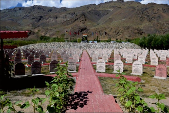
The memorial of Victory of Kargil war of 1999. The Tololing Heights, Tiger Hill, and Point 4875 (Batra Top) is visible where fighting took place during the conflict
The presence of stromatolites in the region attests to early life during the Precambrian period, predating 538.8 million years ago.
The abundance of a wide variety of gems and minerals, including ruby, topaz, sapphire, and others, bestow economic importance upon this area.
The Parkachik Glacier in Suru Valley is an ideal site for the study of glaciers, conveniently situated along the route. Similarly, the Drang-Drung Glacier at Dolma Point stands as the highest pass in the region and is easily accessible via the road.
A novel approach to geo-heritage study through aerial routes has been initiated for the exploration of Zanskar Valley. This method provides a clear view of various features of the mountain range. The study holds the potential to contribute to geomorphic studies of glaciers, climate change, and our understanding of glacier retreat, among other aspects.


A) Apricot, locally known as “chulli” in Ladakhi, “Khubani”in Kargil and Kashmir. B) A typical Ladakhi long tailed mouse known as Himalayan marmot. C) Yak is “Tartary ox,” a species of long haired domesticated cattle found throughout Himalayan high altitude regions. D) An interesting probably archaeological site near Zangla village where Kioto limestone is etched by the ancient people (? ) depicting the local animals—mountain goat or ibis. E, F, G) Typical flowers of Zanskar. H) A typical tribal people of Zanskar valley
Near Zangla village, on the banks of the Zanskar River, ancient people have carved images of local animals, such as mountain goats or Iberis, onto e Jurassic–Kioto lime stones. These limestone carvings feature a variety of intriguing figures, providing evidence of human habitation on this land since ancient times.
Remarkably, the region has preserved its flora, fauna, ancient culture, ethnic diversity, folk customs, and traditions in pristine condition
This area holds historical significance as the site of the Kargil War, and it is home to the Kargil War Memorial, honoring the martyrs of the conflict. The region is renowned for its apricots, locally known as 'Chulli' in Ladakhi language and 'Khubani' in Kargil and Kashmiri languages. Centuries ago, Chinese traders traveling the Silk Route introduced and popularized this fruit in the region. Today, apricots have become an integral part of the local culture, heritage, and economy.
One of the unique animals found in this area is the Himalayan marmot, also known as the long-tailed Ladakhi rat. It can weigh up to 9 kg, with a length ranging from 5 to 31 inches.
This region has been a treasure trove of medicinal plants since ancient times and has served as a primary source of medicinal herbs for numerous traditional medicine systems, particularly within the Asian traditional medicine traditions. One of the most prominent traditional medicines in the Trans-Himalayan regions of the Indian cold desert is the Amchi system of medicine, often referred to as Tibetan medicine. Those who practice this ancient healing art are known as Amchis, regarded as experts in the field.
By
Parul Datt Saxena
Credit:
Geoheritage Merits of the Zanskar Range of the Kashmir Himalaya: a Field Geology Museum from Precambrian to PresentM. G. Thakkar1 Gaurav Chauhan1 Aadil Hussain Padder1 Suraj Kumar Parcha2 Shubhra Sharma3 V. C. Thakur2 C. P. Dorjay4
Geoheritage (2023) 15:75
https://doi.org/10.1007/s12371-023-00842-9